

ROAD SAFETY ANALYSIS
Alaska Road Safety Analysis
Behavioral Insights Powered by StreetVision
The following road safety report evaluates road risk events in Alaska from January 2026 through March 2026. It examines phone distraction rates, intersection-level hard braking activity, and corridor-level speeding patterns to determine where risk is most concentrated.
The report leverages insights from CMT’s StreetVision, an AI-powered behavioral analytics platform that provides decision-ready insights into roadway risk before crashes occur. Transportation officials use StreetVision to identify hotspots, prioritize high-impact safety interventions, and evaluate the effectiveness of countermeasures.
Here is a snapshot of our findings — covering distraction benchmarking, county-level concentration analysis, high-risk intersection identification, and corridor speeding patterns.
01 PHONE DISTRACTION
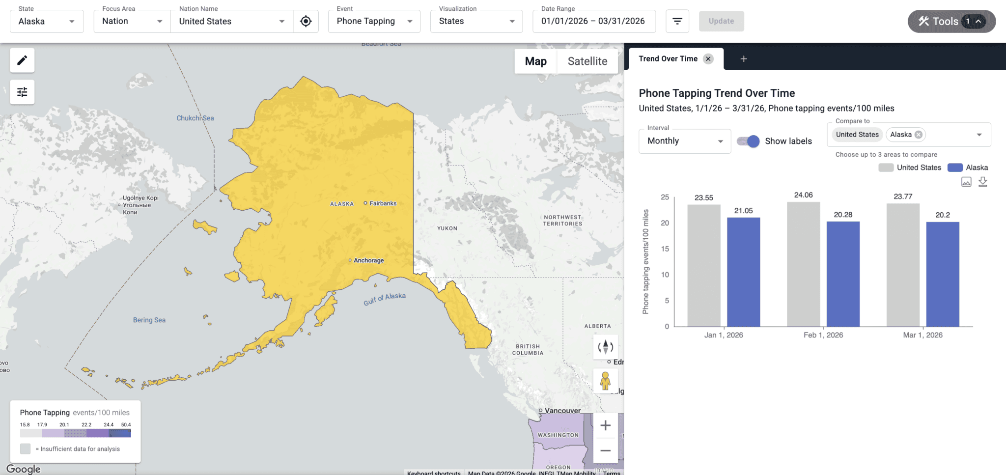
Monthly distraction rates: A comparison to the national benchmark
In January 2026, drivers in Alaska recorded 21.05 phone tapping events per 100 miles, compared to the national average of 23.55, placing the state 10.6% below the US benchmark.
In February, the rate was 20.28, a 3.7% decrease from the prior month, and 15.7% below the national average.
By March, phone tapping events decreased to 20.2 events per 100 miles, marking a 0.4% decrease from February. It was 15% below the US average.
phone tapping events per 100 miles
02 COUNTY ANALYSIS
Borough-level insights reveal concentrated rates of distracted driving
Across the three-month period, Alaska averaged 20.51 phone tapping events per 100 miles, though borough-level data shows wide variation around that benchmark.
The most distracted boroughs, led by Kodiak Island, Ketchikan Gateway, and Matanuska-Susitna, recorded distraction rates roughly 9% – 18% above the state average, highlighting concentrated pockets of elevated risk.
In contrast, the least distracted boroughs, led by Copper River, Denali, and Southeast Fairbanks, reported rates roughly 23% – 31% below the statewide average, underscoring a clear regional divide in driver behavior.
phone tapping events per 100 miles
Highest Distraction
Kodiak Island Borough
24.3
+18.5%Ketchikan Gateway Borough
23.5
+14.6%Matanuska-Susitna Borough
22.3
+8.7%Sitka City and Borough
22.3
+8.7%Chugach Census Area
21.2
+3.4%Lowest Distraction
Kenai Peninsula Borough
18.9
-7.8%Yukon-Koyukuk Census Area
17.3
-15.7%Southeast Fairbanks Census Area
15.7
-23.5%Denali Borough
14.8
-27.8%Copper River Census Area
14.2
-30.8%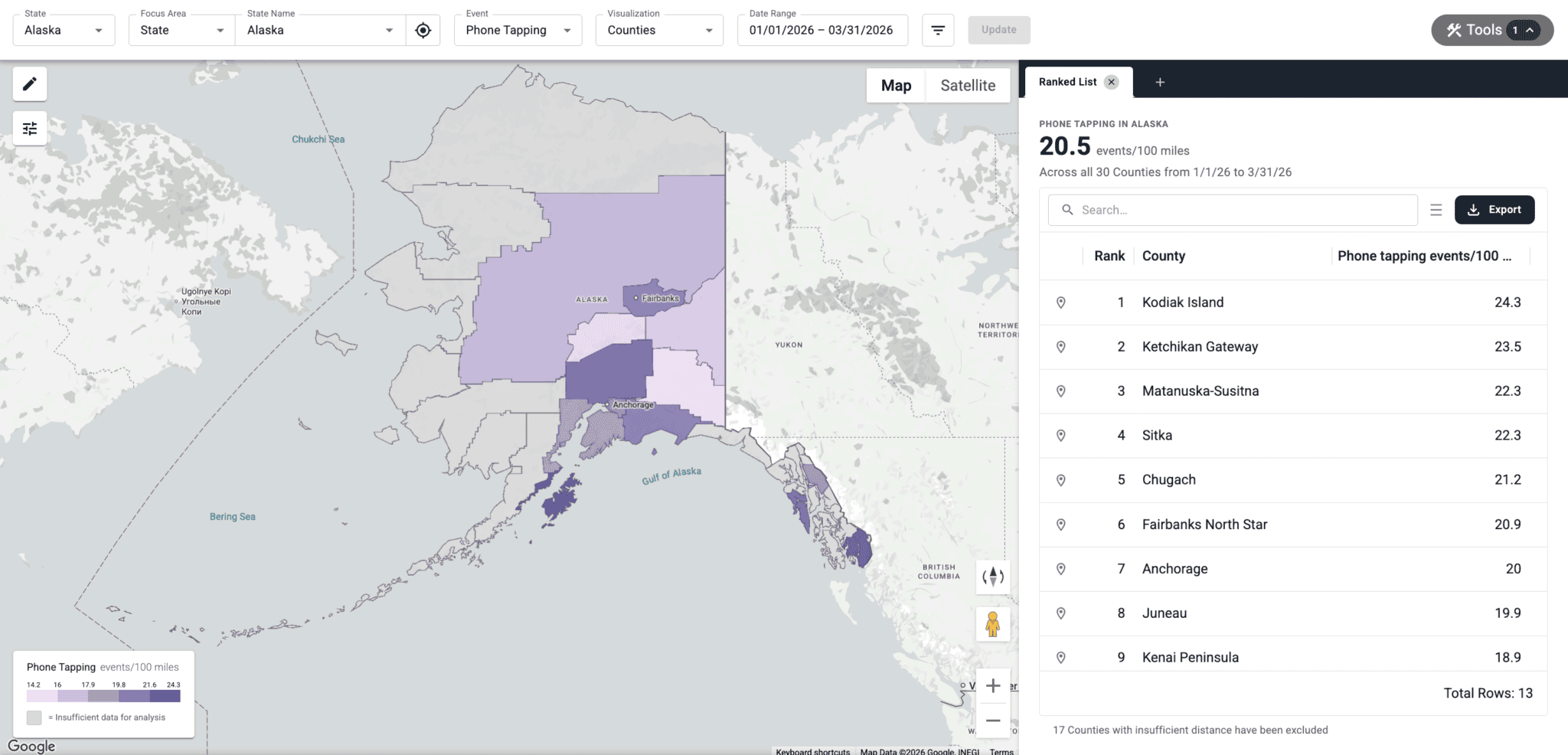
03 HARD BRAKING
High risk intersections: Where hard braking signals elevated crash risk
Intersections account for roughly 25% of all US traffic deaths and 50% of all traffic injuries. Hard braking often signals near-miss events, making it a leading indicator of elevated crash risk.
An analysis of Ketchikan Gateway Borough intersections found Forest Avenue & Schoenbar Road to be a high-risk hotspot, with 163.1 hard braking events per 100 miles driven.
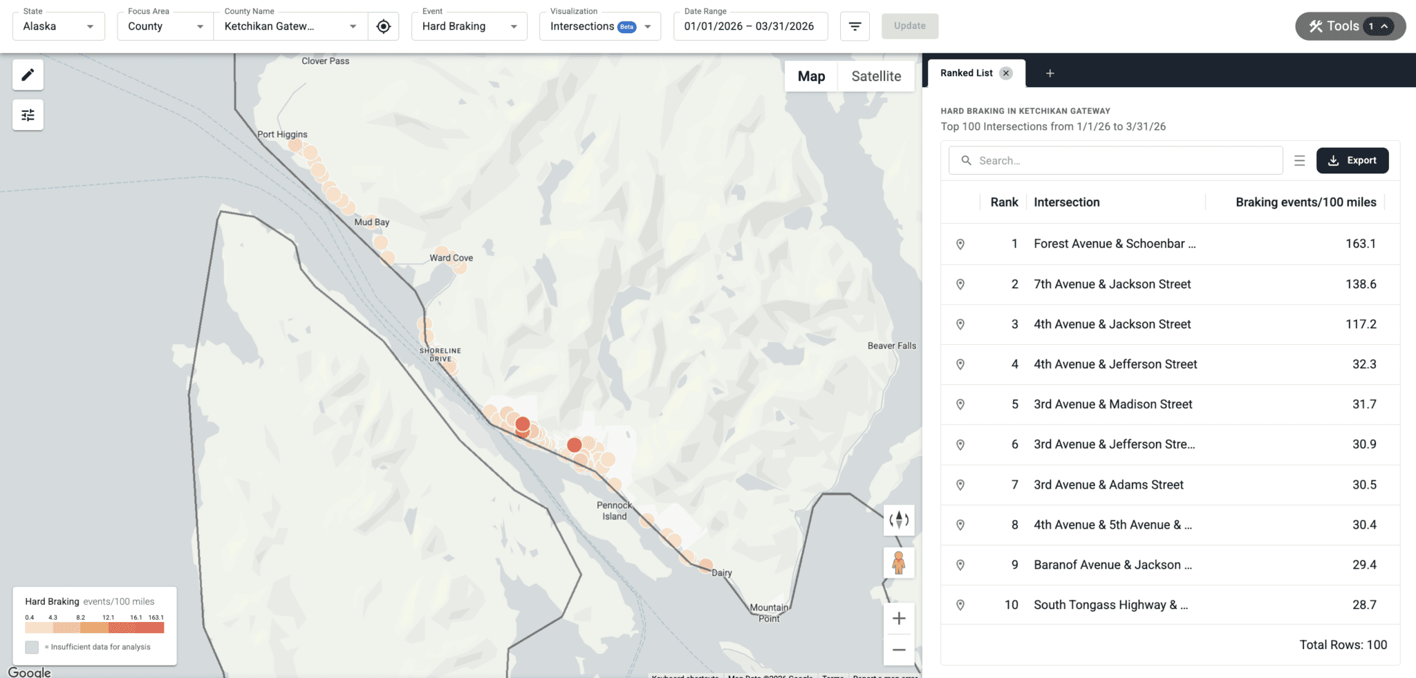
highest risk
Forest Avenue & Schoenbar Road
163.1
hard braking events / 100 mi
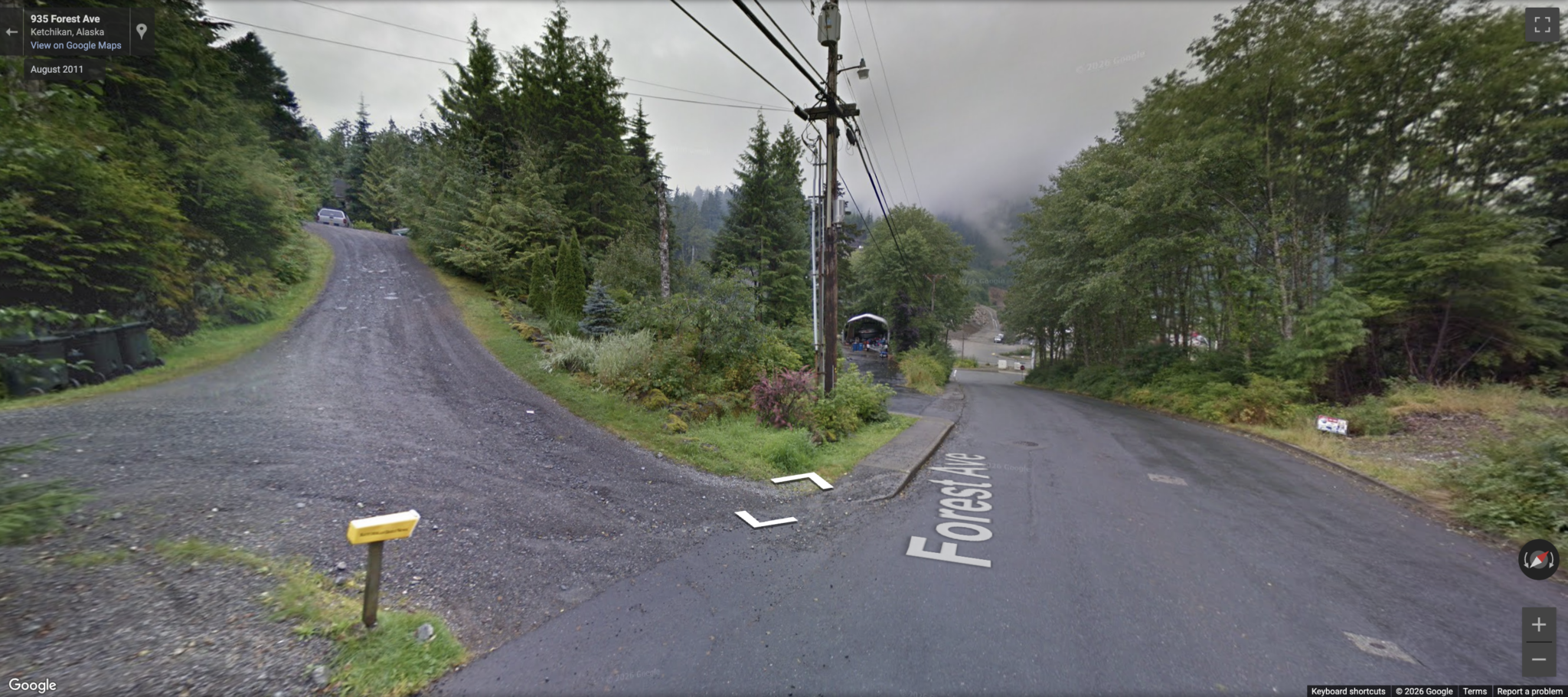
other high risk intersections in Alaska
Hard Braking Events per 100 miles
7th Avenue & Jackson Street
138.6
4th Avenue & Jackson Street
117.2
4th Avenue & Jefferson Street
32.3
Locations with persistently high hard braking activity are widely recognized as candidates for proactive intervention — where targeted engineering improvements, enforcement visibility, or behavioral countermeasures may reduce crash risk before crashes occur.
04 SPEEDING PATTERNS
When & Where Speeding Risk Peaks
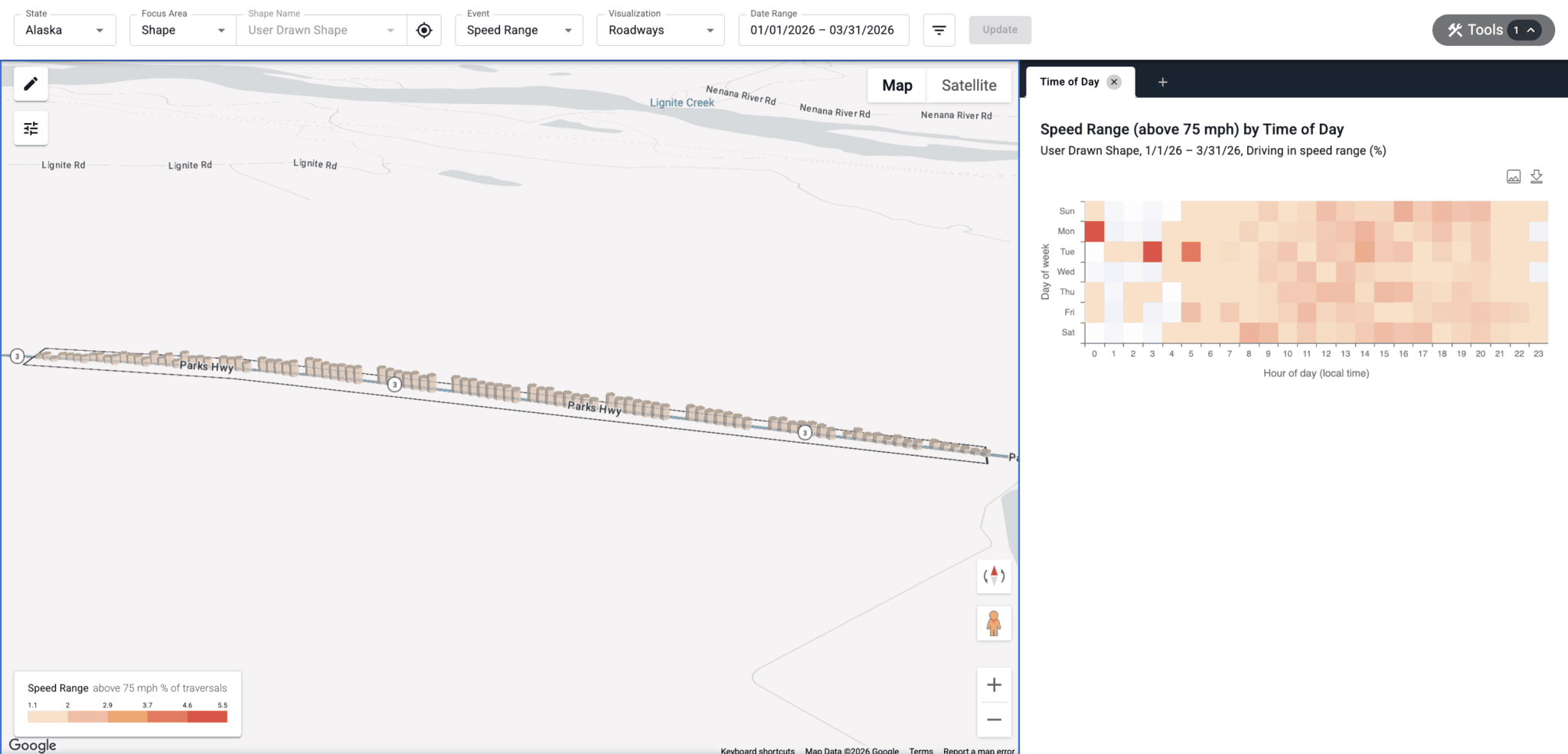
Speeding behavior in Alaska follows identifiable time-of-day and corridor-level patterns, creating predictable windows of elevated risk.
On AK-3 in Denali Borough, AK (65 mph), speeding peaks on Mondays at 12:00 a.m., when 94.4% of driving time exceeds 10 mph over the limit. Additional elevated speeding periods include Tuesdays at 2:00 p.m. and Sundays at 4:00 p.m.
These patterns provide actionable intelligence for speed studies, high-visibility enforcement, public awareness campaigns, and resource allocation decisions.
CORRIDOR ANALYSIS
AK-3
Posted speed limit: 65 mph
Mondays: 12:00 a.m.
94.4%
of driving time exceeds the posted speed limit
Tuesdays: 2:00 p.m.
14.2%
of driving time exceeds the posted speed limit
These patterns provide actionable intelligence for speed studies, high-visibility enforcement, public awareness campaigns, and resource allocation decisions.
05 SCHOOL ZONES
How fast are drivers going in school zones?
We analyzed speed distribution in the school zone at Willow Crest Elementary School on W Tudor Rd in Anchorage, AK. Our analysis found that 6% of drivers exceed the 45 mph speed limit during school hours. Tuesdays at 10:00 a.m. had the highest rate of speeding, with 11.9% of drivers going over the limit.
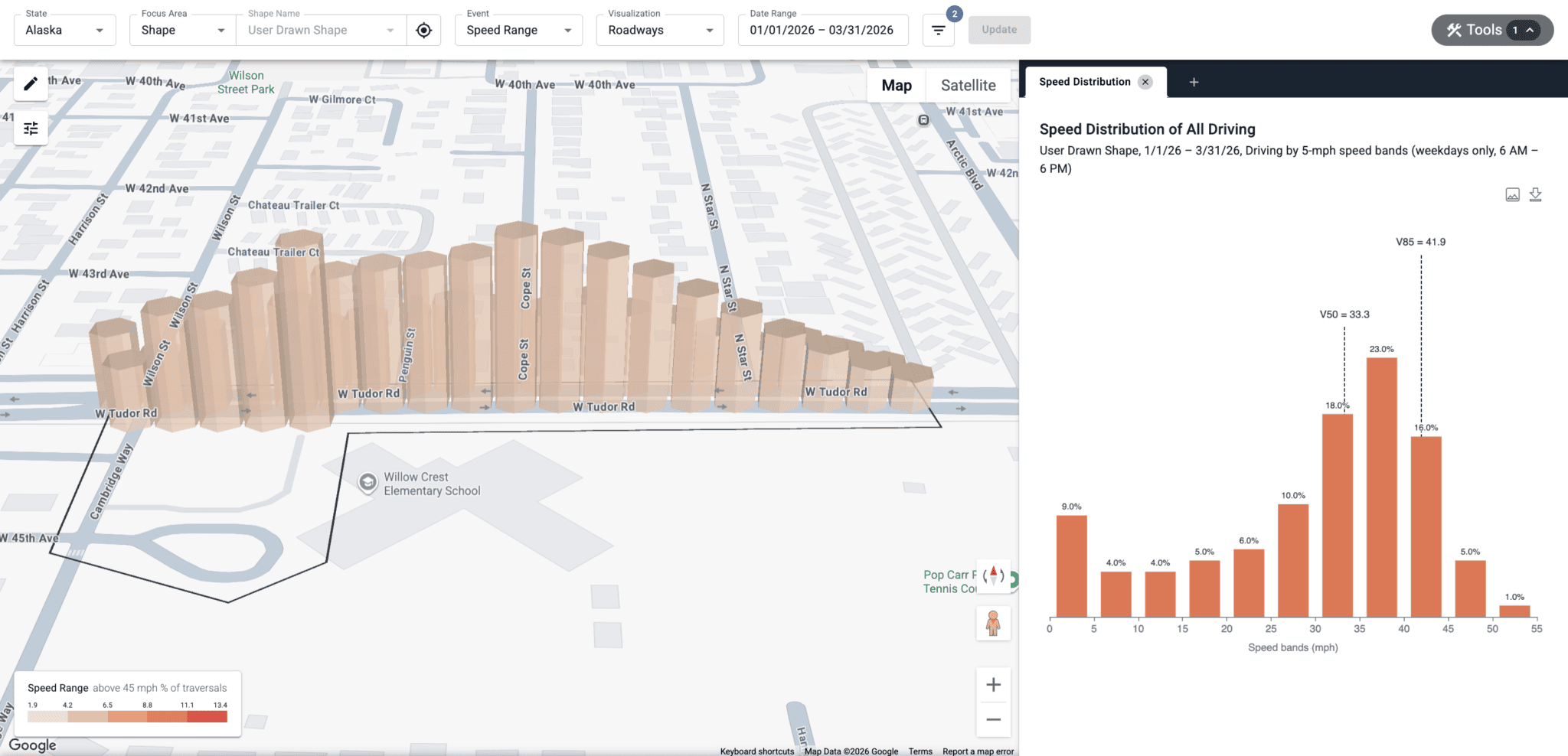
Understanding how frequently speeding occurs during school hours helps traffic engineers determine whether stronger safety measures are needed to better protect vulnerable road users.
StreetVision: The Future of Roadway Safety
You know your roads. Now see what you don't.
See how AI behavioral analytics can help you understand where risk is emerging, why it occurs, and what to do next.