
Before You Drive Vice City: How the Real Florida Drives
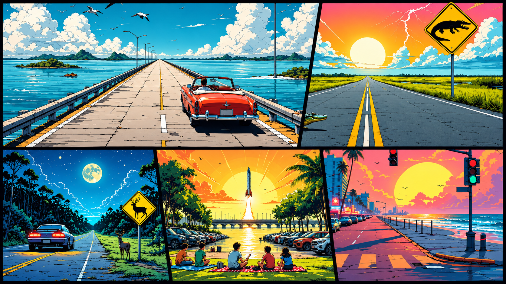
Grand Theft Auto VI arrives today, and its players will put thousands of miles on the streets of Vice City and the bridges of the Leonida Keys: a sun-drenched, neon-lit, thoroughly fictional Florida.
The real Florida is our day job. CMT.AI measures how people actually drive, using the sensors in phones and in small devices fixed inside cars. So before the game takes over everyone’s days and evenings, we looked at the real roads of Miami, the Keys, and the rest of the state, and at what hurricanes, a moon rocket, lobster season, and a Cuban Christmas Eve do to them.
What we found
- At 1:00 AM on Christmas morning, Miami-Dade had five times its usual traffic. Between 10:00 PM and 2:00 AM, hard braking ran about 30% lower per mile.
- After Artemis II lifted off, 50% of driving time near the launch site between 7:00 and 8:00 PM was spent at a standstill, against the usual 15%.
- Before Hurricane Milton, up to 3 in 10 Gulf Coast drivers left town. Of those who left Tampa Bay, 15% ended up in Georgia.
- King tides cut traffic on Collins Avenue in Miami Beach to 47% of its usual speed.
- 42% of driving time in Miami-Dade is spent below 15 mph, against 27% in the rest of Florida.
- On the Seven Mile Bridge, drivers brake hard about once every 900 miles.
- On Big Pine Key, drivers slow down at night for the Key deer.
Miami: late nights, slow traffic
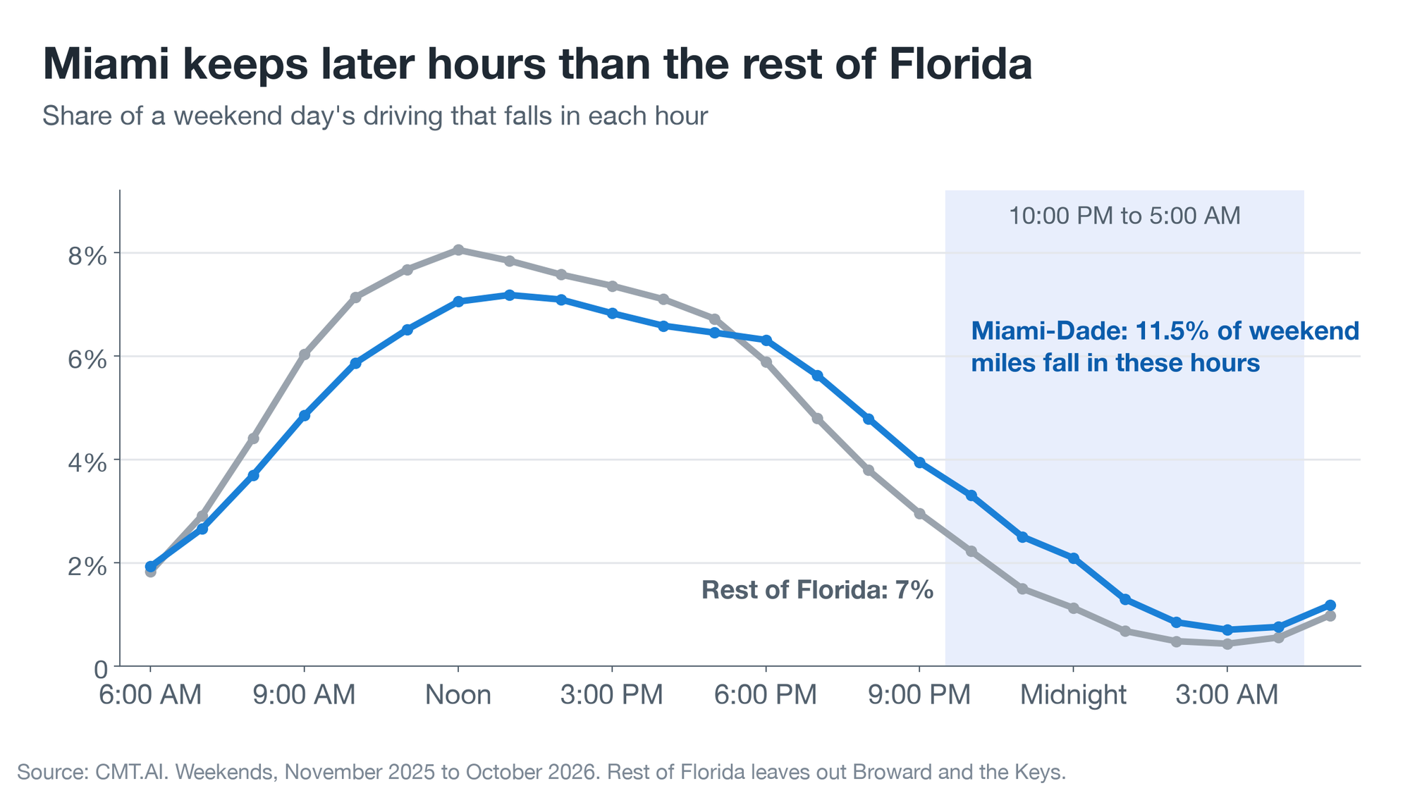
Vice City’s real-world counterpart keeps late hours. On weekends, 11.5% of the miles driven in Miami-Dade County fall between 10:00 PM and 5:00 AM — about 1.6 times the rate in the rest of Florida, where 7% of miles are driven during those hours.
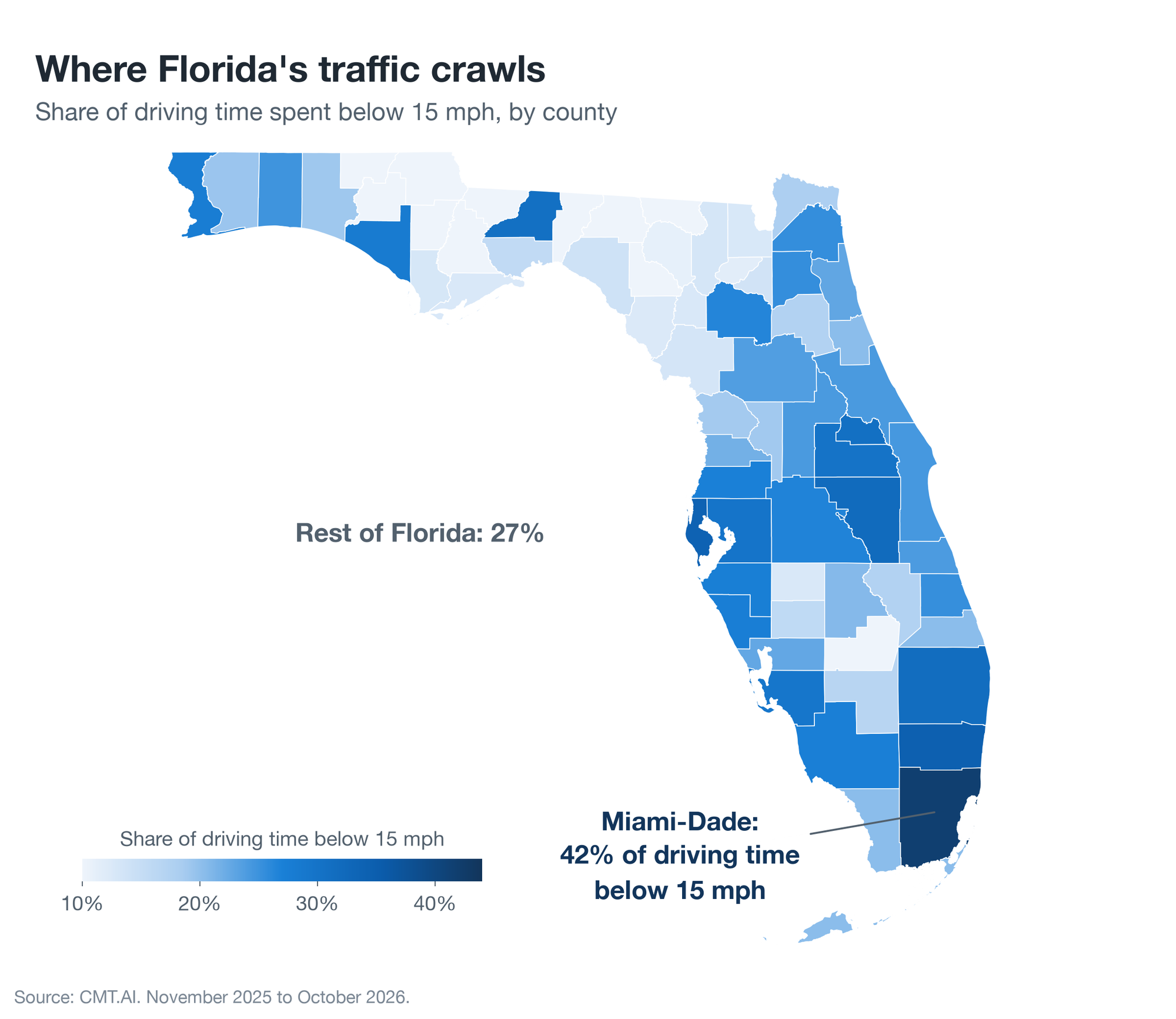
It is also a slow city. About 42% of driving time in Miami-Dade is spent below 15 mph, against 27% in the rest of the state. On the freeways, where nobody plans to crawl, it is 18% against 6%.
Then there is the afternoon downpour. When it rains in Miami, freeway traffic runs about 3 mph slower, and about 5.5 mph slower when the rain is heavy. In the rain, the same Miami drivers brake hard 11 to 13% less often per mile than they do in dry weather.
The Keys: one road, a weekly tide and a careful mile for the deer
South of Miami the map narrows to a single road. US-1 runs from island to island down to Key West, about three hours from Miami (the typical trip takes 178 minutes).
The road has a tide of its own. On Fridays, 58% of the traffic crossing Jewfish Creek, at the top of the Keys, is heading down toward Key West. By Sunday evening it has turned: between 4:00 and 10:00 PM, about 7 in 10 of the miles driven there are heading back to the mainland.
Past Marathon comes the Seven Mile Bridge, which takes a little over seven minutes to cross and gives a driver almost nothing to brake for. Hard braking happens there about once in 900 miles, roughly a quarter as often as on the open stretches of the same road on the islands.
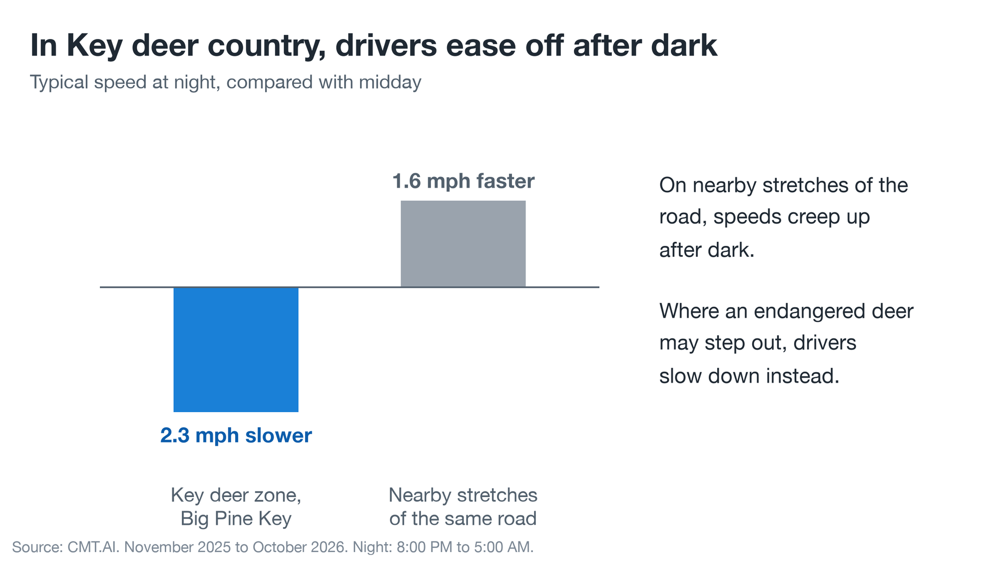
And on Big Pine Key, where the endangered Key deer cross the road, drivers do something they don’t do nearby. They slow down after dark. Typical speeds through the deer zone are about 2.3 mph lower at night than at midday. On neighboring stretches of the same road they are about 1.6 mph higher.
Hurricane season: the week the Gulf coast left town
“I can say without any dramatization whatsoever: If you choose to stay in one of those evacuation areas, you’re going to die.”
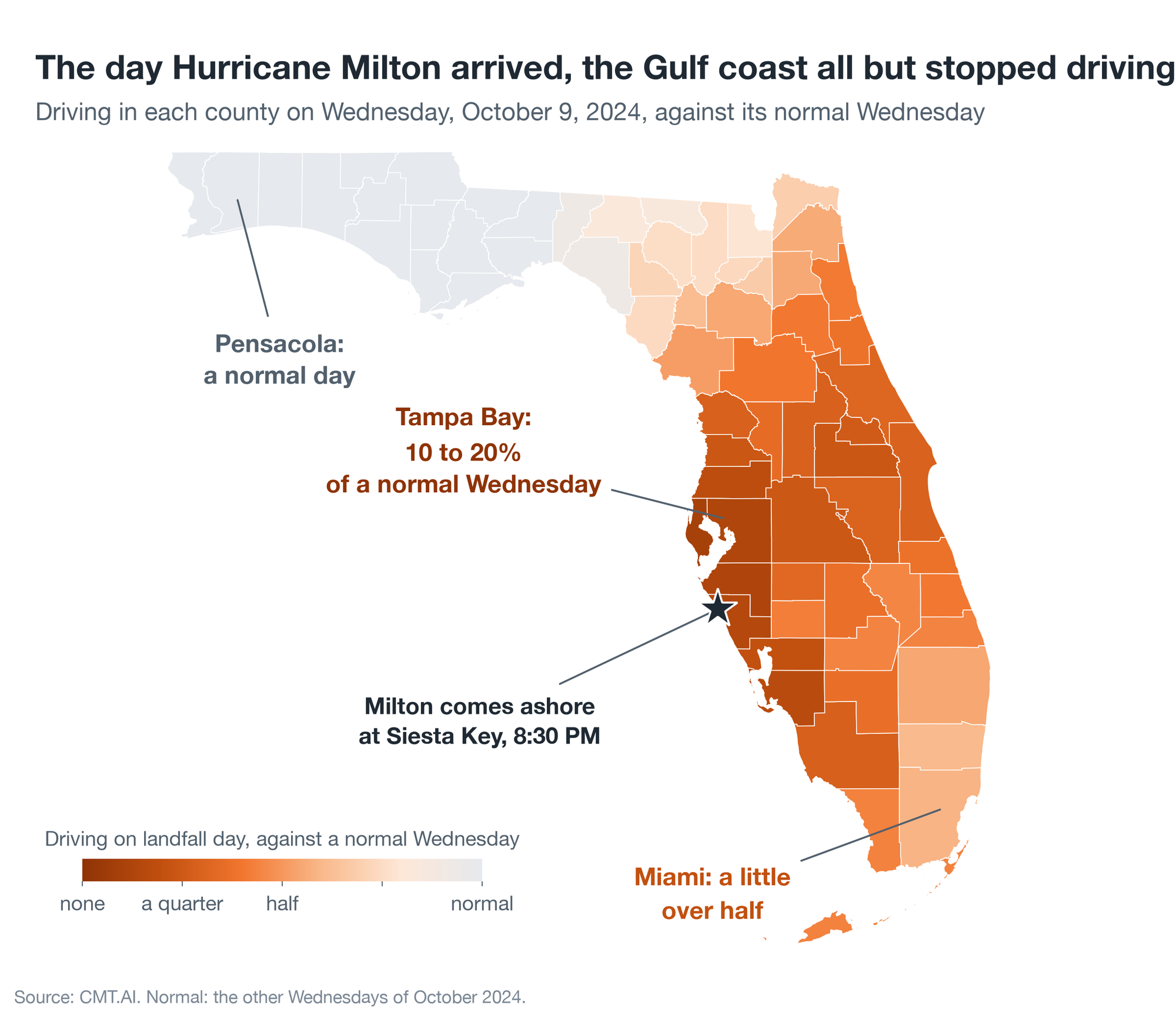
That was Tampa’s mayor, Jane Castor, speaking to CNN on the evening of October 7, 2024 (as reported by Axios). Hurricane Milton was two days away. It came ashore at Siesta Key, south of Tampa Bay, at 8:30 PM on Wednesday, October 9, a Category 3 storm with winds near 115 mph (National Hurricane Center). By the day of landfall, 15 counties, home to more than 7.2 million people, were under mandatory evacuation orders.
As the storm closed in, NPR found a 90-year-old Englewood man, Irving LaLonde, at a gas station, deciding “whether to head further inland, north or south.” “I turned on the television this morning,” he said, “and oh my God, they said, ‘Get out of Englewood.'” He took off, NPR reported, “still unsure of which direction to go.”
Inland, north or south? For the coast as a whole, the cars can answer that.
Who left. In the three days before Milton came ashore, up to 3 in 10 drivers in Tampa Bay and southwest Florida drove more than 30 miles from home. In an ordinary week, fewer than 1 in 12 do.
Where they went. Tampa Bay’s drivers scattered north and east. When Milton came ashore, 15% of those who had left were in Georgia and 10% were around Orlando. From the coast between Sarasota and Naples, the way out ran east across the Everglades: 18% were in Fort Lauderdale’s Broward County, 16% in Miami-Dade, and 9% in Palm Beach County.
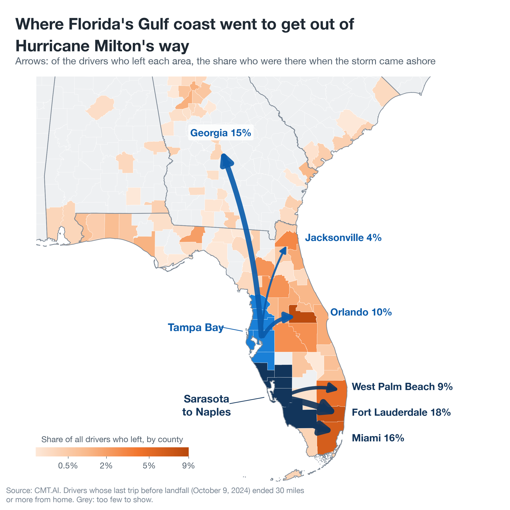
Where they slept. When the storm arrived, at least 1 in 5 of those cars were parked within a block or two of a hotel or motel, and almost none at a campground. The rest were parked where no hotel is on the map, which is where relatives, friends, and rentals are. Distance made the difference. Of the drivers who stopped within about 60 miles of home, fewer than 1 in 10 were at a hotel. Of those who went farther, more than 1 in 5.
The day itself. On October 9, driving in the Tampa Bay counties fell to roughly 10 to 20% of a normal Wednesday. Orlando was down to about a quarter. Miami, on the opposite coast, fell to a little over half. In Pensacola, at the far end of the Panhandle, it was an ordinary day. By the following Sunday to Tuesday, the Gulf coast’s driving was back within a tenth of normal.
What a hurricane does to a car
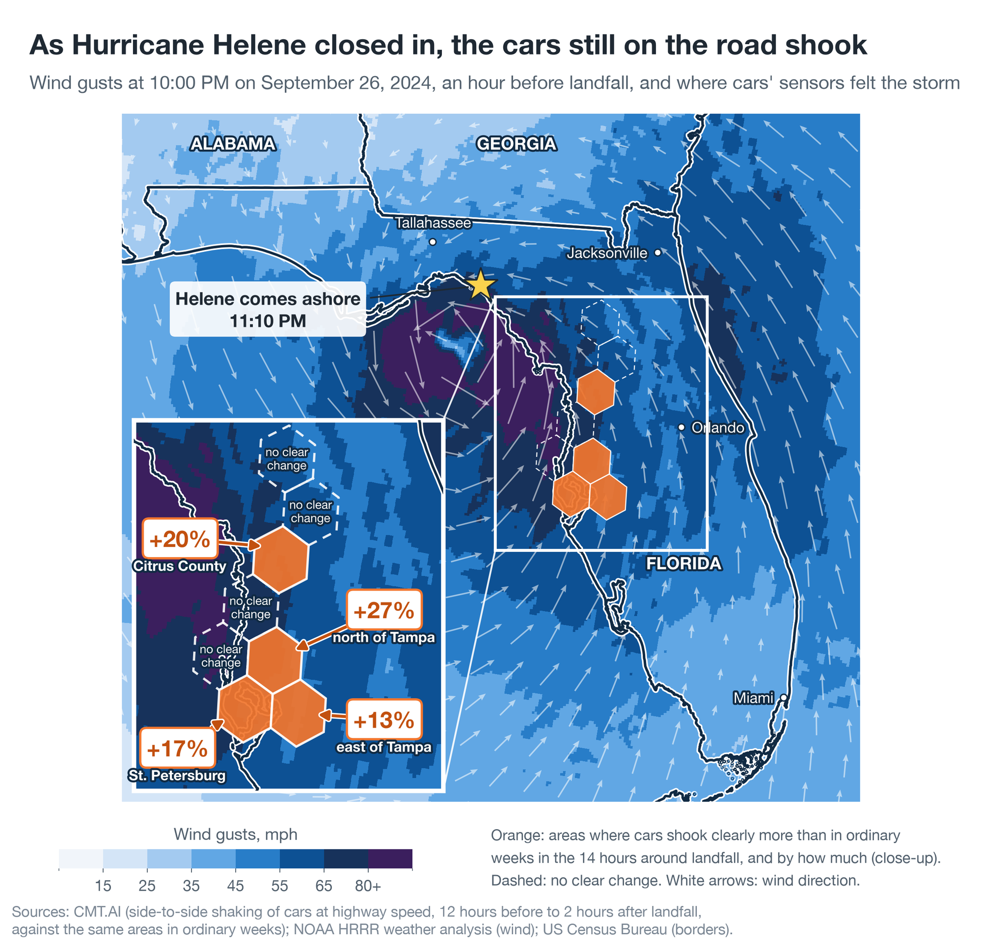
Near the center of a major hurricane the wind blows at well over 100 mph — Hurricane Helene’s reached about 140 mph when it came ashore in Florida’s Big Bend on September 26, 2024 (National Hurricane Center). A storm like that can rattle a moving car long before its eye arrives, and the motion sensors in CMT’s in-car devices pick up the shaking.
The map shows Helene an hour before landfall. The colors are the wind gusts, from NOAA’s hourly weather analysis, and the white arrows show the wind wheeling around the eye. The close-up marks the eight areas where enough drivers were still on the road to measure. Over the 14 hours around landfall, cars there typically shook from side to side 10 to 14% more than in ordinary weeks. In the four orange areas the shaking stood clear of anything their ordinary weeks reach, by 13 to 27%.
In October 2026, Hurricane Isaias left the same mark on the western Panhandle. In the counties in its path, cars typically shook 8 to 20% more than in ordinary weeks, while in counties the storm never reached, the typical place was unchanged at the same hours. Not every storm does it: around Milton’s landfall, the cars still out shook as usual.
The best trip in a hurricane is the one made two days before it hits.
Launch day: the evening a moon rocket stopped the Space Coast
Florida’s Space Coast has sent up more than a hundred rockets in the last year and a half, and most of them barely ripple the traffic. Artemis II was different.
On April 1, 2026, at 6:35 PM, NASA’s Artemis II left Kennedy Space Center with four astronauts aboard, the first crew to travel beyond low Earth orbit since Apollo 17 in 1972. The Brevard County Sheriff’s Office was expecting 400,000 visitors.
They came early. At the riverfront parks, causeways, and beaches where people go to watch, cars were arriving at up to three times the normal rate through the afternoon. On the Titusville riverfront, the typical spectator parked about two hours before liftoff. On the beaches of Cape Canaveral and Cocoa Beach, it was closer to three hours.
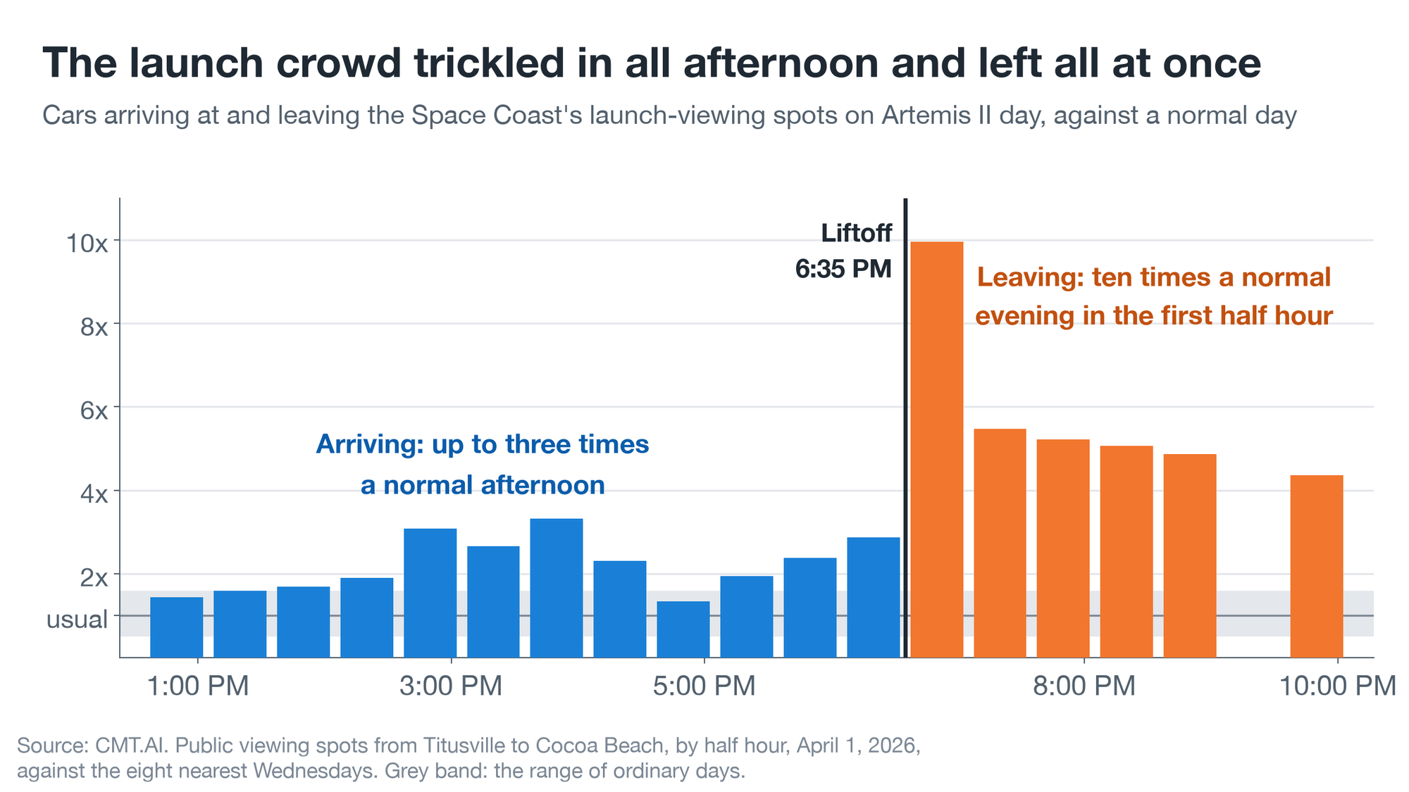
Then the rocket went, and so did everyone else. In the first half hour after liftoff, ten times as many cars pulled out of the viewing spots as on a normal evening. The typical spectator was rolling again within about half an hour. Then they went nowhere. For the next three hours there was about 1.8 times as much driving near the launch site as on a normal Wednesday evening, and between 7:00 and 8:00 PM half of all that driving time was spent at a standstill, against the usual 15% or so.
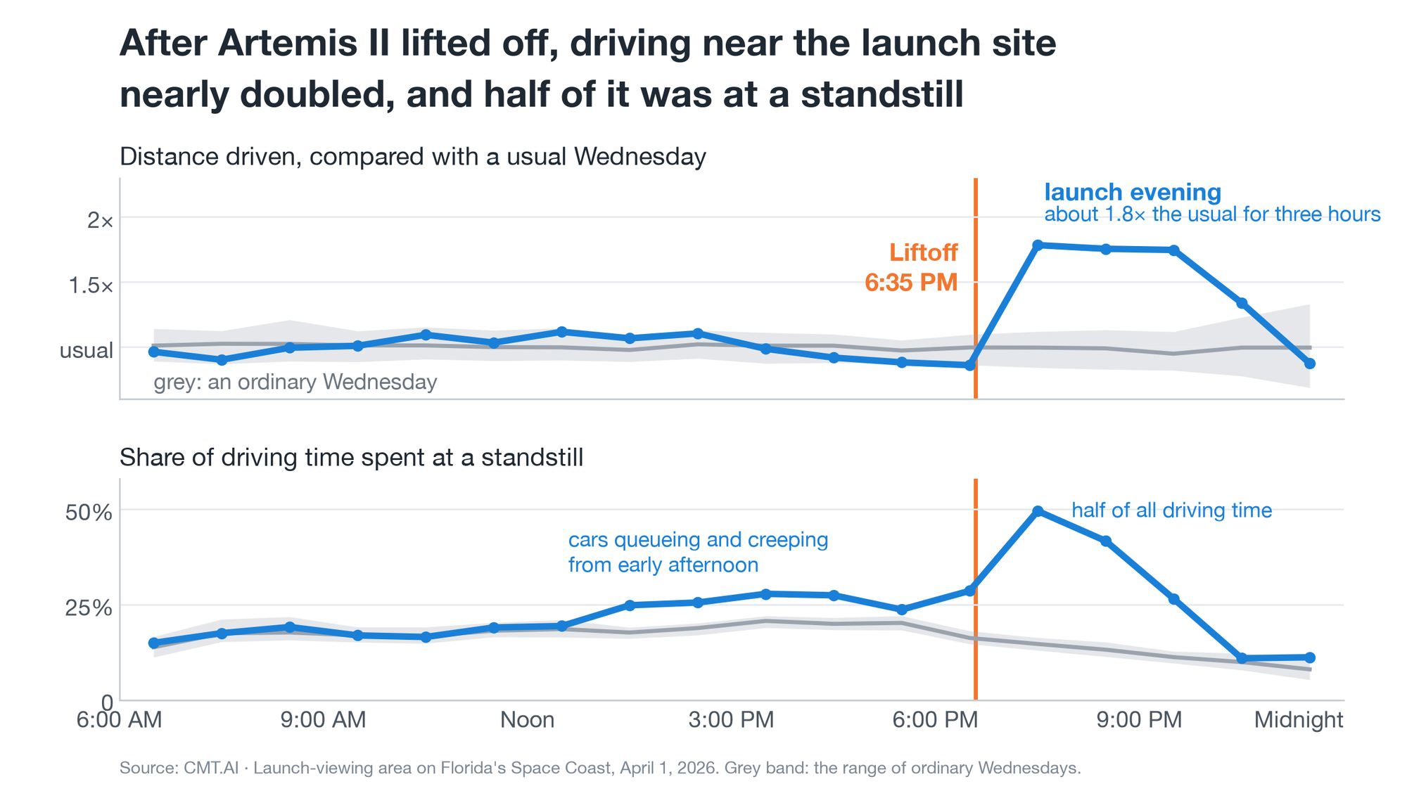
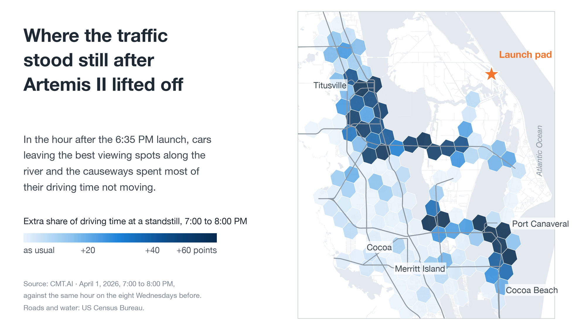
On the causeways, at Port Canaveral, and on the Titusville riverfront, the worst spots reached 70% or more. Local news had warned it could take “a good two to three hours” for traffic to return to normal. It took closer to four and a half hours. The roads were still busier than usual after 10:00 PM and back to normal by 11:00 PM.
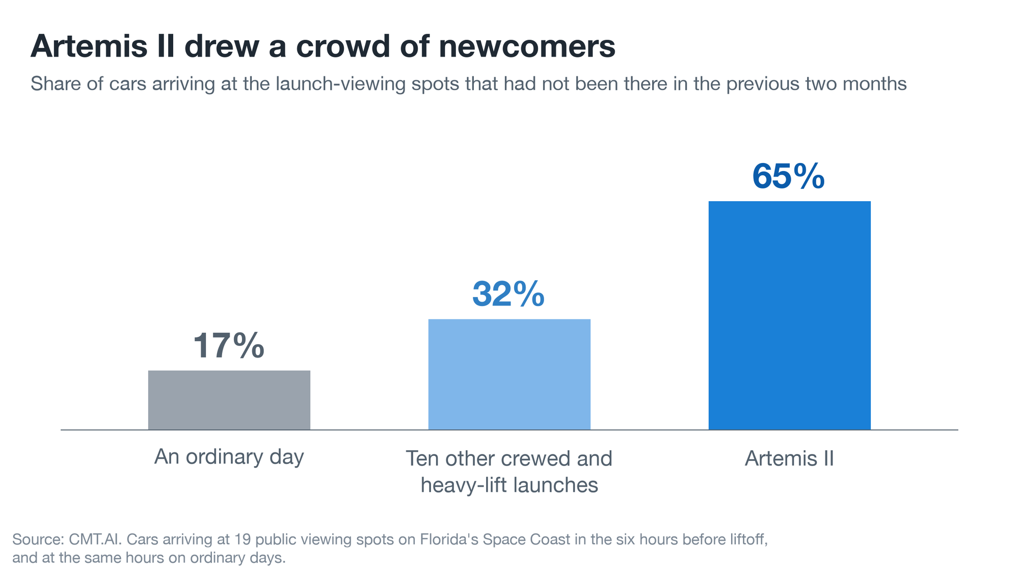
Who were they? Mostly strangers to the place. 2 in 3 of the cars that parked at a viewing spot that afternoon had not been near any of them in the previous two months. On an ordinary day, it is about 1 in 6.
Smaller launches draw a smaller, more local version of the same crowd. Across ten other crewed and heavy-lift launches, arrivals at the viewing spots more than doubled in the two hours before liftoff, cars left at four and a half times the normal rate in the half hour after it, and about a third of the cars arriving were newcomers.
If you go to watch one: park first, then look up.
Nochebuena: Miami’s 1:00 AM rush hour
Few American cities have been shaped by one community the way Miami has been shaped by its Cuban one. The Freedom Tower downtown, where Cuban refugees were welcomed from 1962 to 1974, is known as the “Ellis Island of the South” (National Park Service). Today more than 900,000 people in Miami-Dade County, about one resident in three, are of Cuban origin. You can hear it in the language, taste it in the food, and join it each March when the Calle Ocho festival fills Little Havana’s main street.
It shapes the calendar, too. For Cuban families the big night of Christmas comes a day early. Nochebuena, “the Good Night,” a long Christmas Eve built around a roast pig, often cooked in a box under hot coals called a caja china, with side dishes, desserts, and dominoes.
You can watch it happen on the roads. At 1:00 AM on Christmas morning 2025, Miami-Dade had five times its usual traffic. The night started quiet: around 5:00 PM there was about a quarter less driving across Miami-Dade than on a normal Wednesday. Late in the evening the county got back in the car, and by 11:00 PM there was more than twice the usual driving.
And the drive home? Gentler than an ordinary night. Hard braking across Miami-Dade ran about 30% lower per mile between 10:00 PM and 2:00 AM than on ordinary Wednesday nights. It was not just a different crowd on the road: the same drivers braked less often per mile than on their own ordinary nights, by about a sixth in 2025 and by more than a third in 2024. And it is not simply the holiday timeline: New Year’s Eve was about as busy, and hard braking did not drop at all.
The same streets show up again in March, when the Calle Ocho festival takes over SW 8th Street from 13th to 27th Avenue. On festival Sunday in 2026, the neighborhoods around it carried about 13% more of the county’s driving than on the Sundays either side.
Winter: where the snowbirds land
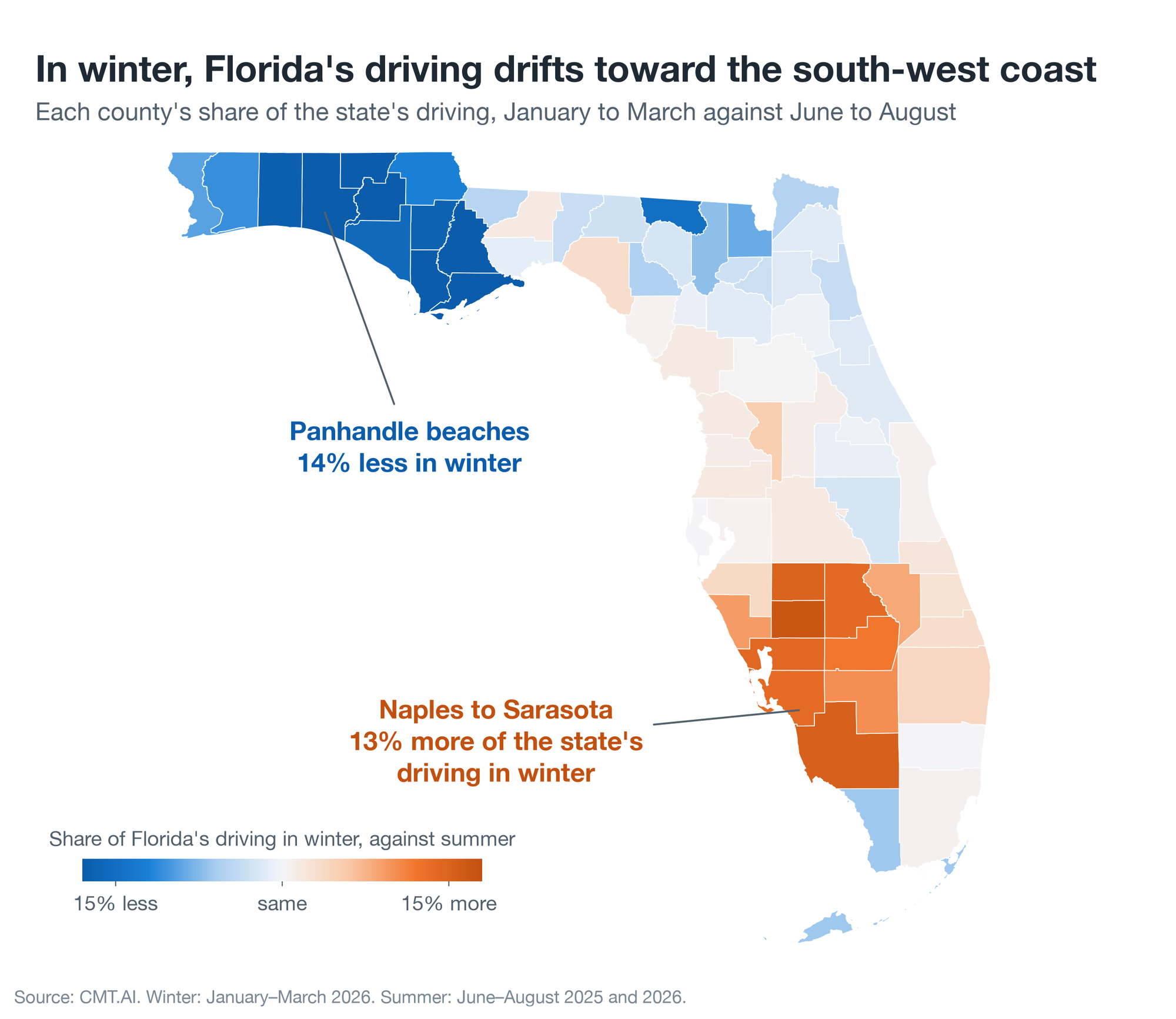
Florida’s traffic migrates with the seasons, the way its winter visitors do. From January to March, the coast from Naples to Sarasota carries about 13% more of the state’s driving than it does in summer. The Panhandle’s beach counties, whose season is summer, carry about 14% less.
Late July in the Keys: lobster season
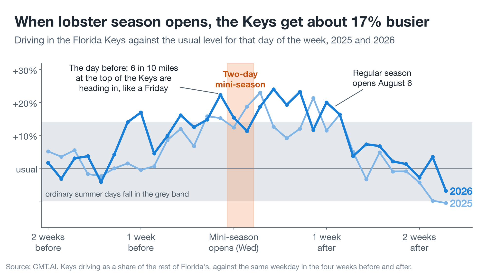
Florida’s lobster season opens with a two-day “mini-season” on the last Wednesday and Thursday of July, a week before the regular season begins on August 6. The Keys’ tourism council calls it “a favorite Florida Keys tradition” that draws “thousands of locals and visitors.”
The road agrees. On the Tuesday before mini-season, about 6 in 10 miles driven at the top of the Keys are heading in toward the islands, a split the road normally sees on a Friday. From that day until the regular season opens, driving in the Keys runs roughly 17% above normal for the time of year. A week after opening day it is over, and traffic is back to usual.
King tides: the street that slows with the sea
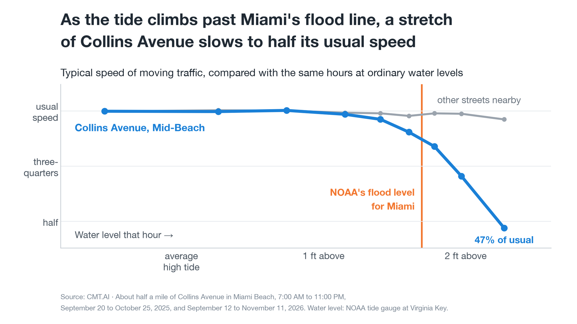
Each fall brings South Florida its highest tides of the year: king tides, when seawater can come up into low-lying streets on a perfectly sunny day. In Miami Beach, most of the city drives on as if nothing were happening. One stretch of road stands out.
On about half a mile of Collins Avenue in Mid-Beach, traffic runs at its usual speed until the water is about 1.3 feet above an average high tide. Then it slows with each further rise. It drops to 84% of usual just past the level NOAA counts as flooding for Miami (about 1.7 feet), to 70% a few inches higher, and to 47% when the water is more than 2.1 feet up. It happened in October 2025, in September 2026, and again in October 2026. Each time the street recovered within two or three hours of the tide turning.
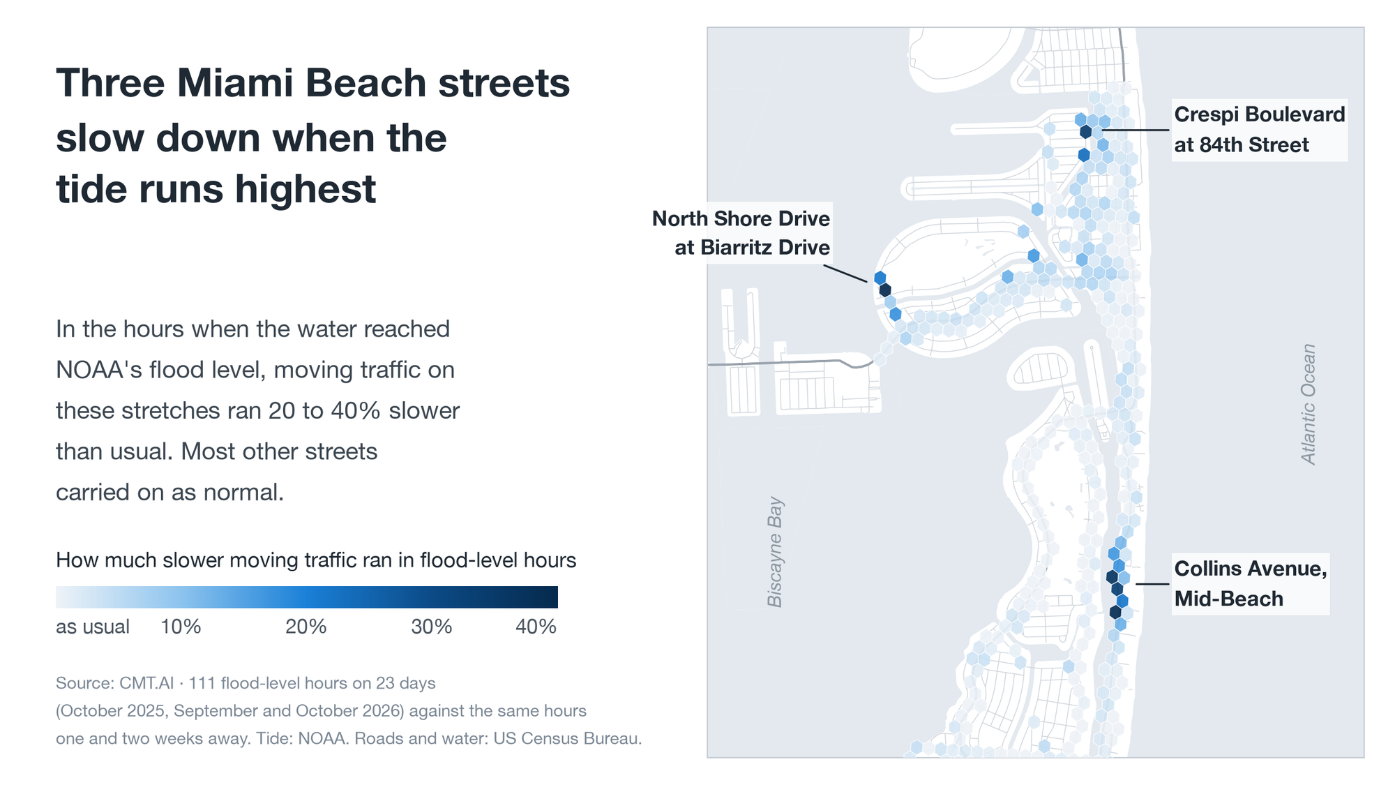
Two shorter stretches further north do the same.
The real thing
Vice City will let you do things with a car that nobody should do with a real one. The real Florida is more interesting anyway. It keeps Miami hours, flows down the Keys on Friday and back on Sunday, empties for a hurricane and fills for a moon rocket. If you take one thing from it onto a real road, make it the drive home on Nochebuena: late, in good company, and gentle.
How we know
CMT’s scientists and engineers have studied the physics of moving vehicles and the behavior of the people driving them for more than 15 years, since the company grew out of research at MIT. A few notes on the statistics behind the figures above:
- The data. Driving measured by phones and in-car sensors in CMT-powered safety programs. Everything here is a total or a share across many drivers.
- Compared with what. “Normal” and “usual” mean the same place at the same hour on the same day of the week, in the surrounding weeks. Where a program is growing, we compare a place’s share of the state’s or county’s driving, so the growth cancels out.
- Could it be chance? Every event here was checked against dates and places where nothing happened: more than 70 other Wednesdays for the launch, every other Florida county, ordinary high tides, the Wednesday before Christmas Eve. We report a pattern only where the real event stands clear of all of them.
- The launch that didn’t happen. For Artemis II we built a stand-in Space Coast from 61 Florida counties away from the Space Coast, weighted so that it tracked the real one hour by hour over the eight Wednesdays before. The gap between the two on launch day is the launch. Arrivals and departures are trips ending or starting within a short walk of 19 public launch-viewing spots, against the same half hours on the eight nearest Wednesdays.
- The storm’s wind. Gusts and wind direction come from NOAA’s hourly weather analysis. The shaking is the side-to-side motion that in-car sensors record on straight stretches of highway, compared with the same roads at the same hours in ordinary weeks.
- Hotel stays. Hotels and motels come from two public map lists, OpenStreetMap and Overture Maps. A car parked within 250 to 800 feet of one when the storm arrived counts as a hotel stay, after subtracting how often an ordinary night’s parking spot falls that close by chance. Both lists miss some hotels, so the true share is higher.
- What the cars can’t tell us. We don’t know who is in a car or why it is on the road. “Left ahead of the storm,” “came for the launch” and “winter visitor” are our reading of when and where the driving happened.
Data: CMT.AI, from drivers in CMT-powered programs, reported as aggregates. Storm, launch, tide and season facts come from the National Hurricane Center, NASA, NOAA, and the Florida Fish and Wildlife Conservation Commission. The illustration at the top is original artwork made for CMT with AI image tools.